Functionalities
This chapter explains the so-called functionalities or functions that fulfil significant tasks within the framework. These are combined into a complex system in order to make the SDSS fully functional and user-friendly. The most important functions are the FormFunctionality, which configures the visible view on the screen, and the PipelineFunctionality, which controls the processes that run in the background.
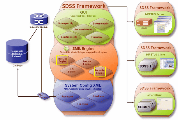
The graph below is a comprehensive illustration of the functionality of a system. The different modules are complementary to each other. Additionally, functional components are available: automatic tools, interfaces for data navigation and for the coupling of models (external and integrated models). The whole configuration is based on the IMPETUS database where all the scientific information was bundled and developed.
It offers the possibility to react flexibly and adequately to clients’ enquiries and expectations.
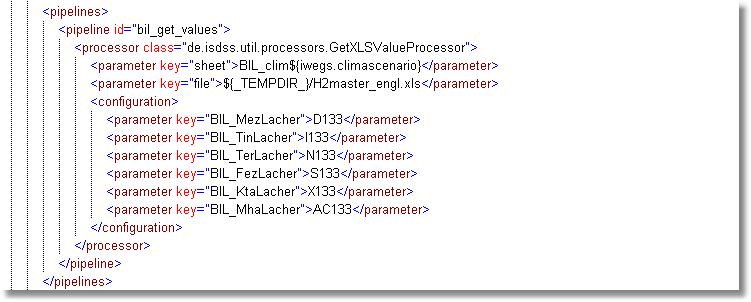
This significant step is also referenced in the XML file. An abbreviated form of - for example - a PipeLine definition in a PipeLineFunctionality will appear approximately like this:
These functions represent the (quantitatively) most complex area of the XML document, but can be reduced to their main elements and ordered in a clearly arranged summary. Two essential functions (Pipeline and FormFunctionality) are highlighted and treated in a special way; please note the links in the table below.
|
|
Description |
||||||||
id |
benimpact.startscreen |
Names the functionality |
||||||||
class |
|
|||||||||
ressource |
benin, mah2, mah5, (...) |
|
||||||||
usergroup |
benin/ maroc |
|
||||||||
nextFunction |
beinimpact.chooser |
|
||||||||
parameter key |
imageid |
|
||||||||
class |
Description |
Creates the presentation and content of the forms |
|
The Pipeline encompasses all the steps in the process which are necessary for modelling and to derive results within the given parameters |
|
This functionality enables the user to navigate within digital maps. Additionally, resultant data can be presented in map sheets. The information remains in the background and allows for a thematic connection. |
|
Graphs can be integrated into the system |
|
Browser windows can be displayed within the system. Here the form of bonding and the format is determined. |
|
(test function for developers) |