Parameter
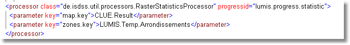
class=de.isdss.util.processors.RasterStatisticProcessor
This processor is based on Geotools and creates statistical information on a geo data object (GridCoverage2D or StyledGridCoverageInterface) into memory. The geo object is stored in out parameters under a given key with postfixes.
Required input parameters:
•Key map.key: the Map to be analysed
Currently following information is put to Output Parameters:
Key$map.key}.maxValue |
maxValue of the Grid |
Key$map.key}.minValue |
minValue of the Grid |
Key$map.key}.avgValue |
avgValue of the Grid |
Key$map.key}.sumValue |
sumValue of the Grid |
Key$map.key}.histogram |
histogram in (default) 20 steps |
Besides this informations, also general raster parameters (e.g. easting, northing, width, height) are put to the output parameter map.