Parameter
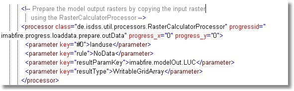
class = de.isdss.util.processors.RasterCalculatorProcessor
This processor performs an (arithmetical) rule on every cell of a raster. For this purpose, references to corresponding cells of other rasters can be used (see RasterCalculator for details).
Required input parameters:
key |
Description |
#0, #1, ... |
References-key to GridCoverage2D- ReadableGrid- or StyledGridCoverageInterface-object. Several of these parameters are allowed. |
F0, F1, ... |
References-key to RasterFilter-object. Several of these parameters are allowed. |
rule |
arithmetical rule on raster data with wildcards '#0', '#1' ... for the raster objects or 'F0', 'F1' ... for filter objects in the list. See OperationTreeParser and RasterOperationTreeParser for details about the syntax and allowed operators. |
resultParamKey |
Output parameter key where the result data is stored in |
style(optional) |
Style the output raster is styled with (if not given, the style is takes from the input grid #0) |
resultType (optional) |
The default is to create a StyledGridCoverageInterface as output. For some (XULU) proposals it is necessary to create a •WritableGridCoverage •WritableGridRaster •WritableGridArray |
Currently at least one existing grid is required in RasterList, also if it is not referenced in rule. It is needed as template (Size, geo-reference, ...) for the result grid. In the future it will be possible to indicate these grid characteristics also by in-channel.